Topsoil maps out salinization
Topsoil: what and why?
Topsoil is a project under the Interreg VB North Sea Region programme. The project aims to better protect the North Sea Region in the future against the effects of climate change. Many daily activities are inextricably linked to the upper layer of soil. Climate change, in fact, impacts the subsoil and the groundwater at an ever-faster rate.
Purpose of the project
The overall aim of this joint interregional project is to study how we can make the shallow subsoil (30 m upper layer of soil) more resilient to climate change.
The solutions developed will be practically implemented in 16 pilot projects across various regions in the North Sea area.
Topsoil in Flanders
Within this project, VMM focuses on the coastal and polder system. Climate change disturbs the balance between fresh, brackish and salt groundwater. Climate change has a twofold impact:
- the predicted drier summers will result in an increased need for fresh water, but also in decreased precipitation excess;
- the rise in sea level will cause the volume of fresh water bubbles in the dunes to decrease and the brackish (saline) pressure in the polders to increase.
This could lead to further salinization and therefore a decrease in freshwater supplies. Knowledge of the degree of salinization is also relevant for future projects and the abstraction of drinking water.
Our subproject therefore consists of two main parts:
- mapping out the fresh-salt water distribution with a helicopter;
- exploratory research into potentials for improving fresh water availability in the shallow subsoil.
Measurements
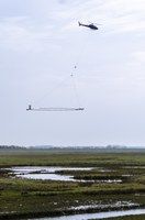
The degree of salinization was measured with a helicopter in the summer of 2017. A helicopter flew along lines systematically spaced 250 m apart. A hoop-shaped measuring probe of 30 by 11 m was attached to the bottom of the helicopter, which flew at a low altitude (65 m) so that the probe hung 30 m above the ground. The helicopter flew at a speed of 30 to 60 km/h.
The electromagnetic field that was emitted allowed us to gather data on the conductivity of the subsoil. These data enable VMM to determine the degree of salinization of the groundwater in the coastal and polder areas.
Topsoil in Europe
The Topsoil project has been set up under the Interreg North Sea Region programme. This is a transnational programme aimed at supporting, developing and promoting sustainable economic growth in the participating countries in the North Sea Region. Cross-border cooperation is essential because climate change does not stop at national borders. Details on the project can also be found in this leaflet.
| Projectpartners | |
|---|---|
| The Netherlands |
Waterschap Hunze en Aa's Waterschap Noorderzijlvest Provincie Drenthe |
| Germany |
Bundesanstalt für Geowissenschaften und Rohstoffe Dachverband Feldberegnung Uelzen Landwirtschaftskammer Niedersachsen Landesamt für Bergbau, Energie und Geologie Leibniz-Institut für Angewandte Geophysik Oldenburgisch-Ostfriesische Wasserverband Landesamt für Landwirtschaft, Umwelt und ländliche Räume Schleswig-Holstein Universität Bremen Geologischer Dienst für Bremen |
| Belgium |
Vlaamse Milieumaatschappij |
| Denmark |
Region Midtjylland (leadpartner) Region Syddanmark Herning Kommune Horsens Kommune Hydrogeofysik Gruppen, Geoscience Aarhus University De Nationale Geologiske Undersøgelser for Danmark og Grønland |
| United Kingdom |
Rivers Trust Norfolk Rivers Trust Essex & Suffolk Rivers Trust Northumbrian Water Ltd. Durham University |
Type project: Interreg VB North-Sea Region
Duration: 01/12/2015 - 01/06/2019


